The U.S. Supreme Court agreed on Monday to decide whether the U.S. Constitution limits how far lawmakers can go to redraw voting districts to favor one political party over another in a case that could have huge consequences for American elections....The unfortunate news is that SCOTUS also stayed that lower court's decision requiring the Legislature to redraw the maps by November 1, which means the current districts stay in place until the decision.
The justices will take up Wisconsin's appeal of a lower court ruling last November that state Republican lawmakers violated the Constitution when they created state legislative districts with the partisan aim of hobbling Democrats in legislative races. The case will be one of the biggest heard by the Supreme Court during its term that begins in October.
The case involves a long-standing practice known as gerrymandering, a term meaning manipulating electoral boundaries for an unfair political advantage. The lower court ruled that the Republican-led legislature's redrawing of state legislative districts in 2011 amounted to "an unconstitutional partisan gerrymander."
A panel of three federal judges in Madison ruled 2-1 that the way the Republicans redrew the districts violated the U.S. Constitution's guarantees of equal protection under the law and free speech by undercutting the ability of Democratic voters to turn their votes into seats in Wisconsin's legislature.
Given that SCOTUS won't rule on the case for the better part of 12 months, it probably makes sense that the districts can't be redrawn before the 2018 elections, which means GOPs get a "mission accomplished" for the 2010s, since only the 2020 elections would be affected (maps will get redrawn anyway after the 2020 Census). Granted, the precedent that could be set would be a much bigger deal in the long-run, as it would give limits to partisan hackery in redistricting. But for Wisconsin politics, the damage from this gerrymander will have already been done.
However, if SCOTUS does get pissed off at WisGOP and feels the need to redraw Wisconsin's districts ASAP, I'm glad to be of assistance. With a huge boost from Twitter superstar/redistricting fan BobbyBigWheel, and the awesome Dave's redistricting website, I worked out a new Assembly map of Wisconsin.
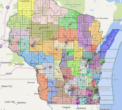
To give a comparison, here's what the current, 99-member Assembly redistricting map looks like.

And here's what my map looks like. I tried to ignore the hometown of a legislator, and generally ignored the partisan leanings of a place. I did keep in mind which areas could be majority-minority districts in the Milwaukee area (both African-American and Hispanic), and tried to keep cities, counties and metor areas together as much as possible.
One of the biggest changes between my map and the current WisGOP one is in Western Milwaukee County, where I tried to end districts at or near the county line. This results in one Wauwatosa-centric district and a district largely based in West Allis/West Milwaukee, instead of the current WisGOP imperialism that splits up Tosa and ‘Stallis into numerous districts, with the voting power of those Assembly districts and Leah Vukmir’s Senate district residing in Waukesha County.

You'll also see that I repeated the pattern on the North side of Milwaukee County, where I put Whitefish Bay, Brown Deer and Glendale together. This avoids the atrocity that we see now where Whitefish Bay is in the district as Mequon and Grafton, and Brown Deer and part of Glendale are in the same district as Germantown and Menomonee Falls. All of these communities are currently "represented" by State Sen. Alberta Darling, who really speaks for the WOW Counties, and not where she lives in Milwaukee County.
I also tried to keep Appleton and Green Bay regions together, particularly on the Senate side (each 3 Assembly seats = 1 Senate district), which is different than the current WisGOP maps where the countryside is included to dilute pro-Dem city votes in those areas.

Lastly, I wanted to make sure suburban and rural Dane County wasn’t being watered down by more conservative districts to the east and north, like the current WisGOP map does. So you’ll see those districts are almost entirely within Dane County, and stay within the Madison TV/radio market. This avoids the issue of having someone like Joel Kleefisch live in Oconomowoc, but “represent” Eastern Dane County under WisGOP's maps.

And while WisGOP would still be likely to hold the Assembly in a 50-50 year under this statewide map, due to “Great Sort” reasons, it wouldn’t be near the absurd levels that they have today, and would result in actual changes of power when the people demand it. That would lead to a level of responsiveness to the public that should be better for a whole lot of us that live in this state. And maybe we could start to get this state back towards sanity and stop falling further behind without any needed changes occurring.
I'd been working on this on and off for about a month as a spare-time brain teaser (yes, this makes me a nerd), but feel free to let me know what you think.
I'm going to take a bit and digest this post, but I wanted to put in a quick thank you for the effort and the links.
ReplyDeleteColor me impressed.
Thanks man! It's not a healthy exercise for most people, but the Dave's redistricting app is quite fun to mess around with.
Delete